The Memory Map of Jewish Manchester
Click here to view the Memory Map
Please note that the Memory Map of Jewish Manchester project is now complete. This was a Manchester Metropolitan University Project and we are unable to update the map ourselves.
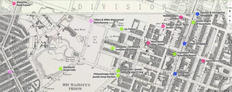
This new digital resource takes the form of an interactive website which maps stories, histories and memories of the Jewish community who once lived in the Cheetham Hill, Strangeways and Hightown areas of North Manchester between the two world wars.
On the interactive map you can discover audio interviews, photographs, and information about more than 40 sites (with the ambition to include more in future as the map builds) that consistently appear in people’s recollections of these areas. These places include shops, synagogues, schools, cinemas, cafes, streets and youth clubs amongst many other places. Some of these buildings no longer exist but the location will be marked on the digital map.
To start exploring, click on one of the coloured circles and information will automatically pop up about that site. To listen to the audio clip, click the play button. Click on ‘Read More’ to view photographs, historical information, excerpts from literature and more.
The open-source platform for this project was developed by the Bartlett Faculty for the Built Environment, University College London for www.jewisheastendmemorymap.org (2020).
The Memory Map of Jewish Manchester was produced by Dr Rachel Lichtenstein of Manchester Metropolitan University, assisted by Paul Darby. The audio clips and copy for each site have been provided by Dr Ros Livshin, oral historian of Manchester Jewry who has also operated as historical advisor and expert throughout this project. The platform has been developed by Dr Duncan Hay.
This project is funded by the Jewish Historical Society of England and the History Research Centre of Manchester Metropolitan University, with support in kind from Manchester Jewish Museum, who gave our permission to use our oral history and photographic collections for this project.
The project would also like to thank the Shloimy Alman archive for the kind use of Shloimy’s photographs of Jewish Manchester in the 1970s and People’s History Museum. An interactive screen for exploring the map is available to view at People’s History Museum alongside the exhibition of Shloimy Alman’s photographs Vanished Streets (October 2021 – January 2022).